
Important Mountain Passes in India & Himalayas, often referred to as ‘La’ in Tibetan, are crucial conduits that facilitate road connections and foster trade across the challenging terrain of the Himalayas. These passes serve as essential links between valleys, allowing for the traversal of mountain ranges and enabling transportation of goods and people. They play a vital role in connecting remote regions and communities, contributing significantly to the socioeconomic fabric of the country.
In essence, Important Mountain Passes in India & Himalayas stand as testaments to human ingenuity and resilience in overcoming geographical barriers. They represent more than mere pathways; they are lifelines that sustain connectivity, commerce, and cultural exchange across the majestic Himalayan landscape.
What is a mountain pass?
Ancient Pathways
Mountain passes have long served as vital routes for trade, military movements, and migrations. These natural corridors, formed between towering peaks, have connected distant regions throughout history. Mountain passes, comprising gaps, saddles, cols, or notches, serve as crucial conduits through rugged terrain. Here’s an exploration of their significance and characteristics.
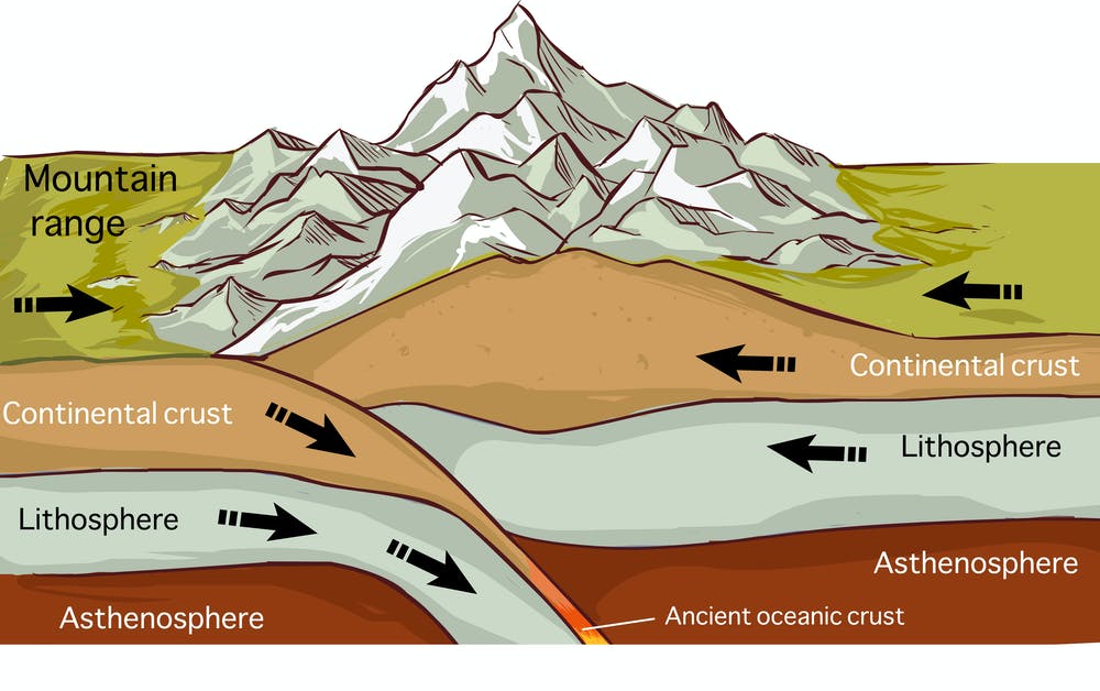
Geographic Formation
Mountain passes are typically formed by volcanic activity or erosion over time. Despite their challenging terrain, they offer the most feasible paths through otherwise impassable mountain ranges. Mountain passes, depicted on topographic maps by hourglass-shaped contour lines, represent low points amidst higher elevations. In high mountains, a 2,000-meter difference between summit and mountain is typically considered a pass. Often located near river sources, passes act as drainage divides. They vary in length from short, steep climbs to lengthy valleys, sometimes identifiable only through surveying.
Strategic Importance of Important Mountain Passes in India
Positioned along trade routes or at key junctions, important mountain passes in India hold immense geopolitical significance. Control over these chokepoints has often been a source of power and contention among nations.
Notable Examples Important Mountain Passes in India
Passes like Khardung La, Rohtang Pass, Nathu La, and Mintaka Pass are important mountain passes in India which serve as crucial links between regions, facilitating transportation and cultural exchange.
Contemporary Significance
In modern times, mountain passes remain vital for transportation and tourism, providing access to remote areas and offering breathtaking views. However, they require careful infrastructure planning and maintenance due to their vulnerability to extreme weather and natural disasters.
Mountain passes, with their rugged beauty and historical significance, continue to play a central role in shaping human civilization and connecting diverse cultures and landscapes.
Transportation Infrastructure:
Passes historically facilitated transportation routes, with roads and railways frequently traversing them. Some, like the Eisenhower Tunnel through the Rockies, feature tunnels to ensure year-round accessibility. The apex of a pass often offers the only flat ground, making it ideal for construction. Additionally, when national borders align with mountain ranges, passes may host border control points or military outposts.

International Borders and Passes: For instance, the Andes mountains form the border between Argentina and Chile, punctuated by numerous passes, exemplifying their role in international boundaries. Roadside signs commonly denote pass names and elevations, aiding navigation. Besides facilitating valley-to-valley travel, passes offer efficient routes between mountain peaks with minimal descent.
Historical and Cultural Significance: Traditionally hubs for trade, communication, and military movements, passes like the Brenner Pass in the Alps have shaped regional history and cultural exchange. Some high-altitude passes face snow-drift challenges, mitigated by elevating roads above ground level to allow snow to blow off, ensuring safer passage.
In essence, mountain passes serve as vital links through formidable terrain, shaping travel, trade, and historical narratives across the globe.
Important Mountain Passes in India:
Important Mountain Passes in India are vital pathways that traverse India’s diverse landscapes, facilitating connectivity and trade. Here’s an in-depth look at some of the significant mountain passes spanning various regions of the country.
Leh-Ladakh Passes:
- Chang La:
- This pass links Leh to Pangong Lake and stands at an impressive elevation of 17,590 feet, making it one of the highest motorable passes globally.
- Notably, the Defence Research and Development Organization is situated near Chang La.
- Bara-Lacha La Pass:
- Serving as the “Gateway to Ladakh,” this pass connects Lahaul and Ladakh, boasting historical significance as a vital trade route.
- Khardung La Pass:
- Acting as a gateway to Nubra Valley, Khardung La Pass plays a crucial role in transporting supplies to the Siachen Glacier is an important mountain passes in India.
- Imis La:
- This pass serves as a critical link between Ladakh and Tibet, marking the commencement of the historically significant Hanle Valley in terms of Buddhism.

Jammu and Kashmir Passes:
- Karakoram Pass:
- Found in the Karakoram Mountain range, this pass connects India and China and has historically facilitated trade between the two nations.
- Pir Panjal Pass:
- Essential for connecting Kashmir Valley and Rajouri, this pass plays a crucial role in transportation between India and Pakistan.
- Banihal Pass:
- Once a significant trail, Banihal Pass now sees traffic diverted through Jawahar Tunnel. Situated amidst picturesque surroundings, it hosts the nearby Zaban Glacier.
- Burzail Pass:
- Linking Astore Valley in Kashmir to the Deosai Plains in Ladakh, Burzail Pass serves as a vital conduit in the region.

Himachal Pradesh Passes:
- Shipki La:
- This pass connects Kinnaur and Tibet, primarily utilized for bilateral trade between India and Tibet.
- Rohtang Pass:
- Rohtang Pass acts as a crucial link between Kullu Valley and Lahaul-Spiti, witnessing heavy traffic during its limited opening window is an important mountain passes in India.
- Bara-Lacha La:
- Crossing the Zanskar mountain, this pass connects Lahaul and Leh, serving as an important trade route historically.
- Debsa Pass:
- Discovered by mountaineers in 1995, Debsa Pass connects Kullu and Spiti, offering stunning views but challenging terrain.

Uttarakhand Passes:
- Mana Pass:
- Part of the Nanda Devi Biosphere Reserve, Mana Pass connects Uttarakhand to Tibet and stands at a staggering elevation of 18,748 feet.
- Niti Pass:
- Joining Uttarakhand with Tibet, Niti Pass has been blocked since 1962, halting trade and travel through this route.
- Lipu Lekh Pass:
- Serving as a crucial border post for trade with China, Lipu Lekh Pass is also a significant route for the Manasarovar Yatra pilgrimage.
- Traill’s Pass:
- Known for its steep and rugged terrain, Traill’s Pass connects the Pindari and Milam valleys, offering a challenging yet rewarding journey.

Northeastern States Passes :
- Nathu La:
- This pass, linking Sikkim with Tibet, serves as a vital border post between India and China, requiring special permits for access is an important mountain passes in India.
- Bom Di La:
- Connecting Arunachal Pradesh to Lhasa, Tibet, Bom Di La Pass offers breathtaking views but limited accessibility due to its strategic location.
- Diphu Pass:
- Situated on the MacMohan Line, Diphu Pass forms a three-country boundary shared by India, China, and Myanmar, making it a site of geopolitical significance.
- Pangsau Pass:
- Located in Arunachal Pradesh, Pangsau Pass facilitates connectivity with Burma, serving as a crucial link between the two regions.

List of Important Mountain Passes of India:
| Name | State | Height (ft/m) | Between/Connecting |
|---|---|---|---|
| Aghil Pass | Ladakh | 16,333 ft (4,978 m) | Gilgit Baltistan – Xinjiang; India-held Aghil Pass north of K2; Depsang Plains in Ladakh – Aksai Chin |
| Auden’s Col | Uttarakhand | 17,552 ft (5,350 m) | Gangotri III and Jogin I in Gangotri Group |
| Banihal Pass | Jammu and Kashmir | 9,291 ft (2,832 m) | Jammu & Kashmir |
| Bara-lacha-la | Himachal Pradesh | 16,400 ft (5,000 m) | Leh-Manali Highway; Near Himachal-Ladakh border |
| Bilafond La | Ladakh | 17,881 ft (5,450 m) | Siachen Glacier |
| Bomdila | Arunachal Pradesh | 7,273 ft (2,217 m) | Tawang & Assam |
| Changla Pass | Ladakh | 17,585 ft (5,360 m) | Leh & Changthang |
| Chankan Pass | Arunachal Pradesh | 7,874 ft (2,400 m) | Southeastern Arunachal Pradesh – India and Myanmar border |
| Chanshal Pass | Himachal Pradesh | 14,830 ft (4,520 m) | Dodra Kwar and Chirgaon (Rohru) in Shimla district |
| Dehra Compass | Ladakh | 17,881 ft (5,450 m) | Inside Aksai Chin |
| Debsa Pass | Himachal Pradesh | 17,520 ft (5,340 m) | Kullu and Spiti districts |
| Dihang Pass | Arunachal Pradesh | 16,965 ft (5,171 m) | Immediate south of Fishtail-II in Dibang Valley district |
| Diphu Pass | Arunachal Pradesh | 15,049 ft (4,587 m) | Southeastern Arunachal Pradesh – India and Myanmar border |
| Dongkhala | Sikkim | 12,000 ft (3,700 m) | Connects to Tibet; Northeast Sikkim; 100 km northwest of Doklam in Bhutan |
| Fotu La | Ladakh | 13,451 ft (4,100 m) | Srinagar-Leh highway between Staktse towards Kargil and Lamayuru towards Leh |
| Goecha La | Sikkim | 16,207 ft (4,940 m) | Westcentral Sikkim within Khangchendzonga National Park; Near India-Nepal border |
| Gyong La | Jammu and Kashmir | 18,655 ft (5,686 m) | Between NJ9842 and Bilafond La on AGPL in Siachen Glacier area |
| Haldighati Pass | Rajasthan | 1,227.03 ft (374.00 m) | Between Kumbhalgarh Fort and Udaipur |
| Hpungan Pass | Arunachal Pradesh | 10,078 ft (3,072 m) | Southeastern Arunachal Pradesh – India and Myanmar border |
| Imis La | Ladakh | 17,355 ft (5,290 m) | India-Tibet border between southeast Ladakh and Tibet; South of Chumar |
| Indrahar Pass | Himachal Pradesh | 14,473 ft (4,411 m) | Near Dharamshala in Himachal Pradesh; Border between Kangra and Chamba districts |
| Jalori Pass | Himachal Pradesh | 10,280 ft (3,130 m) | North of Shimla; Halfway between Shimla and Manali |
| Jelep La | Sikkim | 14,300 ft (4,400 m) | India-China border; Halfway between Shillong in India and Doklam in Bhutan |
| Kalindi Pass | Uttarakhand | 19,521 ft (5,950 m) | Northeast of Guptakashi and southwest of Kedarnath; Heavily glaciated out-of-the-way off-road pass |
| Karakoram Pass | Ladakh | 18,176 ft (5,540 m) | North of Daulat Beg Oldi; Connects northcentral Depsang Plains in Ladakh with Xinjiang; Passes with Xinjiang and Aksai Chin |
| Khardung La | Ladakh | 18,380 ft (5,600 m) | Leh and Nubra; Just east of Parpik Pass |
| Khunjerab Pass | Ladakh | 17,582 ft (5,359 m) | In Gilgit Baltistan; Passes with Xinjiang; Depsang Plains in Ladakh; Passes with Xinjiang |
| Kongka Pass | Ladakh | 16,965 ft (5,171 m) | East of Gogra; On India-China LAC in Chang Chenmo Valley; Adjacent to the disputed Aksai Chin region |
| Kumjawng Pass | Arunachal Pradesh | 9,609 ft (2,929 m) | Southeastern Arunachal Pradesh – India and Myanmar border |
| Kaldang Kildang La | Ladakh | 13,425 ft (4,092 m) | East of Kargil; Halfway between Batalik and Mulbekh |
| Kunzum Pass | Himachal Pradesh | 14,931 ft (4,551 m) | Between Batal & Losar; Connects Lahaul & Spiti valleys |
| Lamkhaga Pass | Himachal Pradesh | 17,336 ft (5,284 m) | |
| Lanak Pass | Ladakh | 17,933 ft (5,466 m) | In Gilgit Baltistan; Passes with Xinjiang; Depsang Plains in Ladakh; Passes with Aksai Chin |
| Lekhapani Pass | Arunachal Pradesh | 13,123 ft (4,000 m) | Southeastern Arunachal Pradesh – India and Myanmar border |
| Lipulekh Pass | Uttarakhand | 17,500 ft (5,300 m) | |
| Lungalacha La | Ladakh | 16,600 ft (5,100 m) | |
| Mana Pass | Uttarakhand | 18,192 ft (5,545 m) | |
| Marsimik La | Ladakh | 18,314 ft (5,582 m) | |
| Mayodia Pass | Arunachal Pradesh | 8,711 ft (2,655 m) | |
| Mintaka Pass | Ladakh | – | In Gilgit Baltistan; Passes with Xinjiang; Depsang Plains in Ladakh; Passes with Aksai Chin |
| Muling La | Uttarakhand | 18,599 ft (5,669 m) | Connects Uttarakhand to Tibet |
| Nama Pass | Uttarakhand | 17,100 ft (5,200 m) | Nanda Devi Biosphere Reserve |
| Namika La | Ladakh | 12,139 ft (3,700 m) | |
| Nathu La | Sikkim | 14,140 ft (4,310 m) | Sikkim and Tibet |
| Niti Pass | Uttarakhand | – | |
| Palakkad Gap | Kerala | 750 ft (230 m) | Kerala and Tamil Nadu |
| Pangsau Pass | Arunachal Pradesh | – | Southeastern Arunachal Pradesh – India and Myanmar border |
| Parpik Pass | Ladakh | – | In Gilgit Baltistan; Passes with Xinjiang; Depsang Plains in Ladakh; Passes with Aksai Chin |
| Pensi La | Ladakh | – | |
| Pir-Panjal Pass | Jammu and Kashmir | – | |
| Rezang La | Ladakh | – | |
| Rohtang Pass | Himachal Pradesh | 13,051 ft (3,978 m) | Manali and Lahaul |
| Sasser Pass | Ladakh | 17,753 ft (5,411 m) | Nubra and Siachen Glacier |
| Sela Pass | Arunachal Pradesh | 13,700 ft (4,200 m) | Dirang and Tawang |
| Sengottai | Kerala | 690 ft (210 m) | Travancore and Tamil Nadu |
| Shashi La | Ladakh | 13,989 ft (4,264 m) | |
| Shingo La | Ladakh | – | |
| Shipki La | Himachal Pradesh | 12,900 ft (3,900 m) | |
| Sia La | Ladakh | 18,337 ft (5,589 m) | Siachen Glacier |
| Sin La | Uttarakhand | 18,028 ft (5,495 m) | |
| Spangur Gap | Ladakh | – | |
| Tanglang La | Ladakh | 17,583 ft (5,359 m) | |
| Thamarassery | Kerala | 1,700 ft (520 m) | Malabar and Mysore |
| Traill’s Pass | Uttarakhand | 17,100 ft (5,200 m) | |
| Umling La | Ladakh | 19,300 ft (5,900 m) | |
| Yonggyap Pass | Arunachal Pradesh | – | |
| Zojila Pass | Ladakh | 12,400 ft (3,800 m) | Kashmir and Ladakh |
Conclusion: Important Mountain Passes in India have historically played a pivotal role in trade, transportation, and cultural exchange, shaping the region’s history and development. From the towering heights of the Himalayas to the verdant landscapes of the Northeast, these passes continue to be essential conduits for connectivity and collaboration.